Destination: Mt. Puting Bato and Canibad, Island Garden City of Samal
The Route
 Climbing a mountain peak is never been an easy task, there are challenges along the way and keeping the pace is an important thing to consider to reach the peak at a scheduled time. Two weeks ago, an adventure event was created and the goal was to reach the highest point in Samal Island which is the Mt. Puting Bato with a height of 410 MASL situated in Brgy. Guilon, Island Garden City of Samal. But here's the twist, we will be conquering the peak not by hiking but through mountain biking, this made the experience an extreme adventure one. Below is the trail we took during the event.
The Challenge
With 13 challengers, almost 50km of Samal trail, more than 400 meters above sea level, rough road paths, and the dangers waiting ahead reaching the highest peak, the question will be if it is a mission accomplished or a mission failed? Let's find out as I narrated this extreme experience we had in this event.:D
 |
| At Sasa 11 Ferry Wharf |
 |
| On board bikes in the ferry |
We gathered around 0600H at Sasa 11 Ferry Wharf and then off to Babak port, the starting point of our trail. From the pier, we immediately started the leg and after few kilometers there's the ascent part, we changes our gears as we slowly climb the road, until reached the top, and a descent this time. With my state-of-the-art mountain bike (surplus bike of more than 10yrs with rust on the frame, basically no suspension, thin brake pads, the latest among others, ahaha) I constantly gripped on the brakes during downhill parts to maintain the speed. Arrived at the road crossing, we waited for the others to regroup and finally proceeded to Penaplata district to buy some foods and had a refill of water.
 |
| The Challengers |


 |
| Penaplata pit stop for food and water refill |
From the Penaplata town, we headed eastward where no more paved roads and the start of the ascent. The climb was really exhausting and there's some point that we need to walk with bike because most of us couldn't make it on some of the uphill part. We had pit stop at a small store and again had our refill and took some rest. After few minutes, we continued on the trail and this time longer uphill road to be taken until we reached another pit stop, not in a store but in a place overlooking the island, the view and the breeze of the wind was great, of course, photo ops wasn't missed. After some time, we continued on the trail and reached the Aundanao-Tayapoc intersection, another photo ops this time before our last leg to the peak of Mt. Puting Bato.
 |
| Overlooking view |


 |
| Group shot at the intersection |
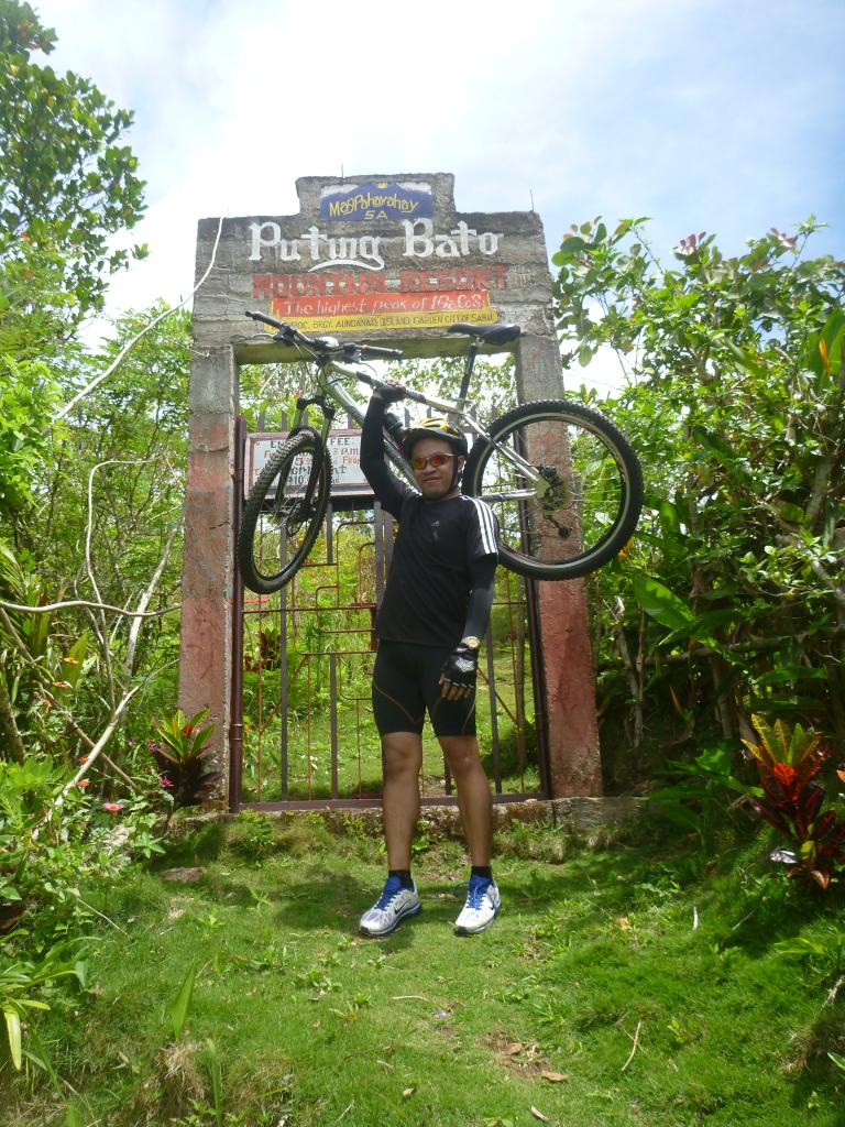
Aundanao-Tayapoc Intersection To Mt. Puting Bato Peak and Vice Versa
The peak can be access via two trail, the Guilon Trail and Tayapoc Trail, we chose the latter since its the ideal trail for mountain biking, while the first trail was rather a short trail good for hiking. This will be our last leg of the trail to reached the highest point of the island and surely this was also the most exhausting part, the longest uphill path we had and the only thing we could do is to push our bike and walk until to the plain. Took a rest every now and then, had some bike ride if possible but before we could finally reached the peak there is the yield part of the trail, there was a not-literally-a-beehive since it houses a wasp along the trail. We need to pass slowly and carefully that it would be not be disturbed with an interval pace. When it was my time, I slowly passed its nest just a meter from the bike and unexpectedly, my friend who's following my pace got stung with the wasp. Unintentionally, he dropped his bike near the wasp's nest and created a road block for the rest of the group. Six of us proceeded to the gate of the peak and had our photo ops. Now, the problem will be on how could passed the wasp territory back to the other group. And finally decided to create a detour road along the bushes and trees just to avoid the stung of the wasps. Once we regroup, we had our individual photo ops with a background overlooking at the entire island.


Aundanao-Tayapoc Intersection To Canibad
Upon descending, we decided to take our lunch on one of the store, some of us just bought biscuits with tunas and sardines for a meal. 3 members of the group decided to go back with the trail we had for shorter time and the rest of us decided to have a detour on Canibad, a pristine white sand beach part of Samal. From the intersection, there is a kilometer ascent first and finally a very long stretch of downhill rough road. Although this is a relaxing part, this is also a dangerous part where anytime you could lost control with your bike, a stone may damage your sprocket or derailleur or you could stumble on some of the road holes and boom, you could be flying with your bike on air. We executed a cautious ride by maintaining a safe distance interval with other bikers and constantly gripping the brakes. Finally, we reached Canibad, our second destination of this extreme adventure.


Canibad To Babak
Before we could reach the shoreline, we still need to trek down the very steep stair by foot with our bike going to the beach shoreline. Finally, a blue, crystal clear seawater welcome us. We took a rest, some of them decided to take a dip for a few minutes. Before 1600H, we decided to continue our trail and went back to Babak. From Canibad, we navigated the road near the shoreline, passing some community towns, walking on some of the uphill parts and decided to go on convoy since its getting dark and some of us had no bike lights and blinkers. After around 1830H, we finally reached Babak proper and then off to ferry boat. At Sasa 11, we parted our ways since I'm living in the north side of the city while most of them on the downtown proper.


Summary
After the extreme adventure we had, I could say that it was way over mission accomplished, we did not just conquered the highest peak of the island but we also gain friends along with. We tested our individual strengths and perseverance for enduring the whole trail. And most of all, thank God for keeping us safe and guiding us the entire trip. "An adventure is only an inconvenience rightly considered. An inconvenience is only an adventure wrongly considered." - Gilbert K. Chesterton

Thank you and God bless us all!
i congratulate you for completing a great adventure ride. hope to join you in your future rides. reading your blog made me more eager to do an adventure ride here in davao.
ReplyDeletethanks, yup, it's really an extreme and fulfilling adventure... you're welcome to join in our biking group. just pm me your contact at rey1011@gmail.com and i will add you to our biking event in facebook. :D
ReplyDeleteWOW! gusto din akyatin 'to... thank you for sharing... :)
ReplyDelete